The
Gravone snowfield.
photo gallery (ita)The Gravone
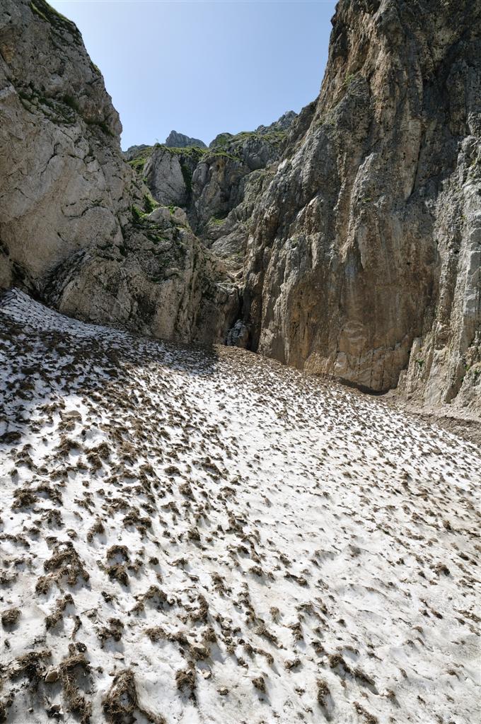
snowfield is situated in the Gran Sasso chain, under the ridges that
go from Mount Camicia, Tremoggia (2331 m), Forchetta di Penne and
Dente di Lupo. It turns towards north-east and its height goes from
1700 m. to about 1900 m., varying from season to season. The whole
snowfield is boxed between high walls and it lays on a bed of a
great quantity of rock debris that guarantees an efficient draining
with no rivulets or fusion torrents, nothwithstanding its largeness,
especially in the beginning of summer. Very often there is falling of
rocks and debris from the walls and from the natural terraces that
are on top of the snowfield and that can even cover part of the
snowfield.
The supply
of the snowfield is principally from avalanches (in a small part
direct), most of all thanks to the significant watershed surface that
conveys to the Gravone every avalanche that comes from all the
numerous canals that we find between the top of Dente del Lupo, of
Mount Camicia and Mount Tramoggia. Since this part of the Gran Sasso
is exposed almost exclusively to precipitations coming from the
“east” that is the gregale formed by the Ionio/Baltic
depressions, the amount of snow may vary considerably from year to
year so that in the years when the circulation of the air originates
principally from the west, the “suffering” of the snowfield is
already evident in the beginning of summer with very reduced surfaces
and depth. These climate conditions, together with its not very
favorable exposition (it has sun for most of the morning, both
directly and from the reflection of the vertical and light colored
walls close by) and its not high altitude has often and willingly
mined its survival, especially after the 90’s.
Its
dimensions were significant during the 60’s and 70’s (at the end
of the season it could reach a lenght of 250 – 300 mt. and a width
of 30 – 40 mt. After, the hot summers and not very snowy winters
(period between 1989 – 1997) have notably reduced its dimensions so
that it “disappeared” during the long and very hot summer of
1998. After that it never recovered and it forms itself depending on
the conditions of the winter seasons. A revival was noticed from 2004
to 2006, but, like all the appennine snowfields, it disappeared again
in 2007 (we are not excluding that a nucleus of firn has survived).
In its place we see only dry stones and part of the valley has been
colonized very quickly by herbaceous plants and shrubs. At the
beginning of the season (end of May – middle of June) the Gravone
snowfield goes past the Gravone canyon and covers part of the stony
ground down in the valley (about 1400 – 1500 mt) almost up to the
edge of the woods and it reaches a second snow tongue formed by
avalanche debris that comes from Mt. Coppe and Tremoggia.
As the warm
season proceeds, the two tongues divide itselves, but while the left
one disappears, the one that comes from the Gravone withdraws into
its real “see”, that is the ending part of the canyon, in the
altitude from 1850 to 1650 mt., where more protected and deep, it can
reach and survive the next summer. In the more snowy years (for
example in the 2005 - 2006) the snowfield can remain connected to the
one on the left even in July (as we can see in the photos at the end
of this article). Its dimensions in August can reach 150 mt. in
lenght. We hope for better situations so the snowfield can form
again.
During the
last glaciation there were hanging glaciers that coming down the
walls of Mount Tremoggia would flow in the gully of the Gravone
forming an ice tongue, that perhaps went under the 1200 mt. while in
the PEG the Gravone was surely an important and visible snowyglacier.
2008: has survived
Fabrizio Sulli, 8-8-08
With the
permission of the CAI (thank you Cristiano!)
Data of the
CAI section of L’Aquila 09-26-1982
Collection
basin: 2 sq km (about 2470 mt)
Ablation
zone: 1,5 sq km (about 1200 mt)
Starting
from the top the snowfields are:
1°
snowfield: 300 sq mt – 3 mt deep (2020 mt)
2°
snowfield: 70x30 mt – 8 -10 mt deep (1840-1900 mt)
3°
snowfield: 300 sq mt. – 4 mt deep (1760 mt)
Domenico
Alessandri, the author of the article assumes that in favorable
seasons there is a snowfield that connects the two other ones.
Infact, up
to the altitude of 1770 mt, there is an area covered by debris and
without vegetation.
Article
kindly revised by Dr. Massimo Peocci.
To reach the
snowfield you must go along the road that connects Rigopiano to
Castelli, when you reach a very tight bend where the road has become
narrower for a landslide coming from the mountain above the road. You
will notice the white rock just discovered. If you stop near the
landslide you should be able to see the snowfield in the center of an
amphiteater, in a wood, and the gully to walk through.
The bend
cuts this gully, so you can park even at the base, or in the close-by
picnic area with benches.
The trail is
not indicated, if not only for a sign that says “follow the trail”
and some hard-to-see indications in the woods, that disappear shortly
after. From this moment on you must be careful, and keep on the
bottom of the gully following the traces of the trail where the
vegetation is less, and keep to your right. Going a little further on
you will be out of the woods and walking across thick vegetation you
will reach the scree and then the snowfield. Interesting is the
blossoming of the peony and the sorb of the fowlers, as well as the
ash and beech trees.
Watch out
for the belladonna!
If you want
to, from here, using harpoons, if necessary, you can continue towards
the mountain, on the snowfield.
When on your
way back, it is easy to get mixed up, you must keep on the gully, and
do not follow the yellow and red indications for trail n. 4 on your
left.
The hike is
easy, it takes about 20 minutes to reach the snowfield (at the
beginning of the season), and about an hour to reach the canyon, the
difficulty is in making your way through the thick vegetation bent by
the avalanches and in some 1° degree passages. Infact in Winter
the Gravone snowfield sends down avalanches all the way to the
tar-road below!
Top part of the Gravone
Antonio Pisanu, 7-8-08