The Calderone Glacier
The Glacier – summer 07 photos (ita) - summer 08 photos (ita)
summer 09 photos (ita)
Pictures (panoramic, front, glacial limo)
Statistic Data Notes - Fonts
NOTE: for summer 2010 click here, for summer 2011 click here, for summer 2012 here. These pages are in italian, but full of photos.
The Calderone Glacier is the only Glacier of the Appennini Mountain Range and it is traditionally considered the most southern of all Europe (about 42° latitude N). It has conquered this record after the extinction of the Corral di Veleta Glacier, in the Spanish Sierra Nevada.
The Glacier was, in the last twenty years, declared extinct many times. Or it was declassified by some researchers while others, instead, classified it as Rock Fossil Glacier.
Using these definitions:
Snowfield: mass of snow
Snowclad: mass of snow and firn
Ice Snowclad: mass of snow, firn and ice. Presence of confirmed for less than 10 years.
Glacier: mass of snow, firn and ice. Presence of ice confirmed for more than 10 years.
The Calderone can be necessarily considered a glacier because is unquestionable that there has been ice for at least ten years (there has been ice for centuries!)
Using instead as a definition “mass of snow, firn and ice with an area of approx. 5 hectares” or other similar definitions, the Calderone can be considered a debris covered glacier, devided into two glacierets; showing evidence of movement.
The Calderone is divided into two sectors since summer 2000.
Data:
|
National Code
|
1006
|
|
International Code
|
4AL00A-A1
|
|
Position
|
Abruzzo Appennines Range, Gran Sasso d'Italia, Vomano Valley
|
|
Hydrographic Basin
|
Fosso Gravone, Mavone, Vomano
|
|
Total Area
|
About 3.5 hectares (about 376737,02 sqft)
|
|
Lenght
|
(Two Parts together) 300 metres (about 984,25 ft)
|
|
Feeding
|
Eolics, from Avalanches, Direct
|
|
Exposition
|
NNE
|
|
Classification
|
Circus Mountain Glacier (pirenaic) - debris covered glacier
|
|
Frontal Activity
|
Undiscernable (the Glacier is in heavy areal, volumetrical and thickness reduction)
|
|
Morain
|
Frontal with ice core
|
|
Maximum Ice Thickness
|
About 25 mt (about 82,20 ft)
|
|
Effective Glacial Surface (2005)
|
About 32.000 sqmt (about 344445,28 sqft)
|
|
Snow Limit
|
Variable (Theorically from about 3100 to 3700 m. a.s.l.)
|
In 2004 the response time was 29 years, the reaction time 8 and the relaxation time 21.
Volumetric and Areal Decrease of Calderone Glacier.
The Calderone Glacier reacts to climatic variations especially by changing its thickness.
|
Year
|
AREA (m2)
|
VOLUME (m3)
|
|
1794
|
104.257
|
4.332.207
|
|
1884
|
90.886
|
3.382.166
|
|
1916
|
63.335
|
3.368.485
|
|
1934
|
59.713
|
2.461.529
|
|
1960
|
60.030
|
1.729.934
|
|
1990
|
52.586
|
360.931
|
| 1999-2000 |
52.070 |
313.843 |
| 2005-2006 |
35.545 |
/ |
| 2007-2008 |
35.545 |
/ |
The volume has reduced more than 90%, area more than 50%.
1920-1990 volume reduction= -0.82 m/year
1995-2005 volume reduction= -1.4 m/year
Glacier mass balance
| 2000-2001 |
- 511 |
| 2001-2002 |
- 1.847 (al minino) |
| 2002-2003 |
-264 |
| 2003-2004 |
252 |
| 2004-2005 |
-194 (al minimo) |
| 2005-2006 |
1.090 |
| 2006-2007 |
-2320 (al minimo) |
| 2007-2008 |
275 |
Alessandro Di Paola
translation by Giuseppe Petricca
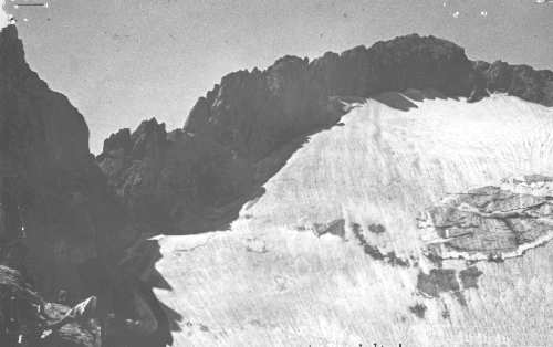
1927, Rovelli’s Archive
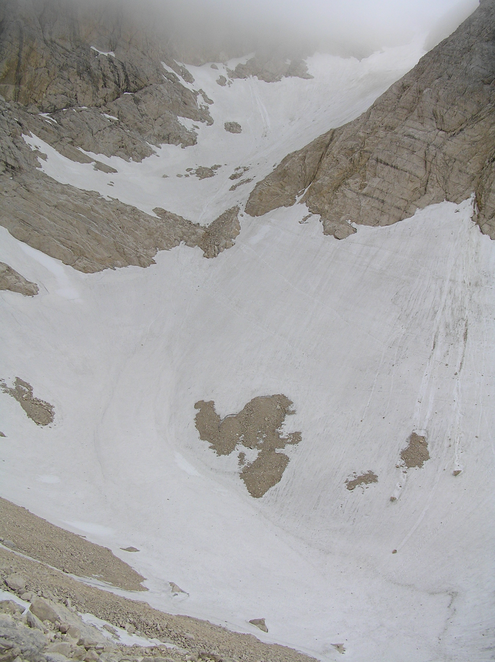
June 2007, Di Paola’s Archive
Links:
website dedicated to the Calderone glacier, historic pictures, last updated 1998
…to be continued.