Snowfields of the Majella
and the Appennine panorama, by Cristiano Iurisci
majella 's photos
This article was published
in the magazine D’Abruzzo in 2004. Here we have the complete
version that was given to us by Cristiano Iurisci.
After the “very hot”
Summer of 2003, words like greenhouse effect, ozone hole, regression
of glaciers and global warming have become very common. These words,
that have a very strong scientific and not completely definite
meaning, have been often used and misused by the mass-media, so that,
after every environmental disaster, they become the only causes and
the only culprit. The discussion is in a matter of fact much more
ample and complicated.
Much has been written and
said, in this regard, about “our” Calderone, that is the only
glacier we have in the Appennine range, situated among the highest
peaks of the Gran Sasso. For some it is considered extinct, for
others in “coma”, and for someone else, it isn’t as serious as
it seems because it is simply half-buried by its own debris. As we
can easily guess, its “survival” is directly proportional to
climate and so to the climate of “our” Abruzzo.
Infact, ice melts at a
fixed temperature set by the laws of physics, which is zero degrees
centigrate; so little variations above this temperature induce its
melting, otherwise its conservation. The constant reduction and
thinning of the Glacier of the Calderone during the last 25 years is
known by all those, scientists and not, who walk next to it when
going towards the peak of the Corno Grande. The older excursionists
remember that in the past a tract of snow had to be crossed even at
the end of August to reach the summit, and now instead, already at
the middle of July it is already a stony ground. This can be a simple
and intuitive method to verify, even in a simplified way and on a
local scale, the thesis of global warming or climate change. Trying
not to make the most common mistakes such as wanting at any cost to
be sensational or catastrophic, what is really the truth? According
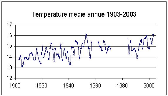
to the official data, there is warming and it is marked enough in
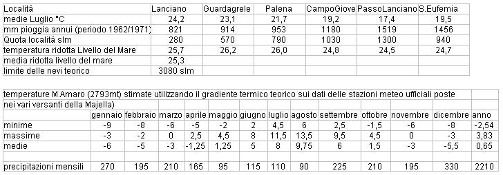
“our” Abruzzo. As we can see in the table below, the average
temperature has gone up about 0.8 degrees in the last one hundred
years (data coming just from Lanciano).
What will happen in the
future is still unknown to us, and even if it is almost certain that
we will be going towards a further warming, the autoregulating
mechanisms of weather are not at all clear and scientifically
demonstrated.
We will not go into the
subject climate both for my incompetence and for the difficulty of
such a subject, but let’s elaborate more thoroughly the “effects”
that it induces in glaciers and snowfields. Climate influences
directly glaciers both in the accumulation (snow precipitations) and
in the ablation (melting of snow), but the “response” of the
glacier to a period unfavorable or favorable to glacialism is
strictly subordinated to its extension and location.
A small glacier
(0,5/2,5 km2)
will almost immediately show the consequences of such variations, on
the contrary, to notice them on a medium-large one (10-1000 km2),
you must wait from several years to a few decades. Not considering
the importance of its location (latitude), you can understand
perfectly that to study glaciers like the Calderone or “snow
glaciers” (subject of this article) of the Majella permit us to
have results that are immediately verified.
The fact is that it helps
us understand if one year was more or less warm, if it was more or
less rainy increasing the interest in their study and their
observation during the years.
Besides the
Calderone there are at least four perennial snowfields on the Gran
Sasso and the same number (or more) on the Majella.On the second, the
highest concentration of snowfields is located between Mt. Acquaviva
(2737 m) and the Peak of the Murelle (2596 m). In Val Forcone we can
find at least four, of which the largest, called by the locals the
“glacier”, is located on the first slope of Val Forcone, at
almost 2200 m. Because of its extension which measures from 90 to 110
m. in lenght and 20/25 m. in width (measurements taken at the end of
the season, usually after the 10th
of September) it can be classified as a snow-glacier. In the same
valley, a little further down, between 2050 and 1950 m. you can
generally find another two small snowfields, usually 30/50 m. in
lengtht and 10/15 m. in width; further down in the valley, where it
tightens like a canyon, there are more snowy heaps, which vary every
year, mostly from 1920 to 1850 m. situated in a suggestive landscape
almost like the moon. This place never stops surprising everyone for
its particular climate, infact in one of the tight and steep canals
that cross the rocky wall of Mt. Acquaviva and that precipitate
directly in Val Forcone, we can find other tight and long “hanging”
snowfields. Up to a few decades ago, some of these snowfields were
connected directly with some of the ones in the valley, forming
snowfields with the characteristic shape of a “Y”. In the last
years (especially after 1990), the unfavorable conditions have caused
its withdrawal and so its “rupture” from the ones in the valley;
and infact today we find them at 100/150 m. higher, while the ones
that filled the tighter and thinner canals, have completely
disappeared. These snowfields which are located between 2250 m. and
2500 m. have a length that goes from 50/100 m. (the biggest one is
almost 200 m.!) but their width is just 15/20 m.!
After the very warm
summers of 1994 and 1998, some of these have suffered ruptures from
the inside as to appear sometimes as many small snow/ice plaques
separated at parts by steep gravel, not hiding though its original
shape. On the northern side of the Peak of the Murelle we can find
some small perennial snow plaques; here we can’t really speak of
snowfields, both for their small dimensions and for their extreme
variability each year, so that some disappear during winters that are
particularly low in snowfalls or very hot summers. An exception can
be made by the one located in the Valle dell’Inferno, that for its
length and width can be considered a snow-glacier. Located in this
tight valley at an altitude of 1150/1200 m., its dimensions are
length 150 m. and width 30/35 m. It is usually covered by every kind
of debris, but we don’t have photos and “official” details, for
its position, very hard to reach. Always on the northern side of the
Peak of the Murelle, in the spectacular valley of Selvaromana, we can
find other snowfields similar to these. Some are situated at the foot
of the large north wall of the Murelle, at an altitude of about 1600
m. Their small dimensions (they don’t exceed 20/30 m. on each side)
compromise their “presence” at the end of the season so that, in
October 2002, one of them had disappeard and the other was reduced to
a heap of ice of a few square meters, but in October 2003, both of
them reappeared in their normal size. Further up we find the
snowfield of the valley of Selvaromana, located at almost 1400 m.,
next to a small canyon that derives from a crag of the Fusco shelter.
This one, too, undergoes enormous variations because of the type of
its feeding, but, on average, it measures 35/50 m. in length and
15/20 m. in width. If we change location we move towards the Valle
of Orfento where we find a small snowfield positioned in the “mucchia
of Caramanico” at an altitude of almost 1550 m. Its dimensions,
very small in these last years, go from 40/60 m. in length and 20 in
width. In the same valley, but further up, in the basin that
separates Mt. Rotondo from Mt. Focalone, we find another snowfield,
even if it is not always there every year. This one occupies the
bottom of the basin, and in particular years, it can exceed 200 m. on
each side, but, since it is not very protected by close rocky walls,
it disappears completely after particularly unfavorable periods. I
will stop here in my list of snowfields because the other snowy
spots, even if they are numerous in our Majella massif, are of very
small dimensions and not present every year, and so scarcely
important.
What distinguishes a
snowfield from a snow glacier? The former is just an expanse of snow,
more or less wide, that “resists” at least for one season.
Instead a snowy glacier is a snowfield which is larger that resists
for a few consecutive years and that is thicker, almost like a
glacier, generally around 800 gr/dm3.
Practically a snowy glacier is almost
a glacier only that it doesn’t have some of its typical
morphological characteristics, like superficial fractures and the
sliding towards the valley.
From our school
books we remember that the limit of perennial snow at our latitudes
is 3000 m., so how is it possible that we have so many snowfields in
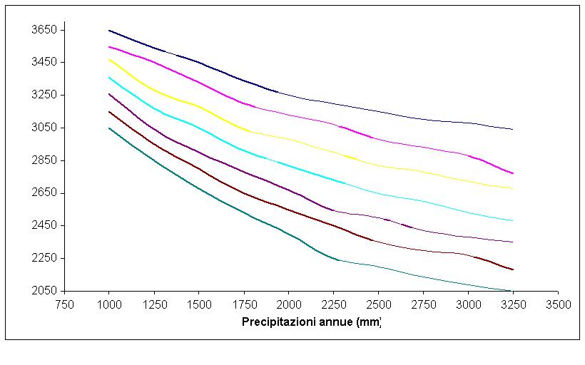
our mountains? If we look at the graphic below we can understand that
there are two important factors to set the parameters for the limit
of snow: annual precipitations and summer temperatures. For the
Majella massif, the extimated precipitations on Mt. Amaro (the peak)
are about 2200 mm per year, while the temperatures during the month
of July brought down to sea level are 25.3°C. With these
parameters the limit should be around 3090 m., and only in
particularly rainy and, at the same time, cold years the limit would
go down to 2800 m. The years that are favorable to the formation and
conservation of snowfields would be rare; the answer to our question
comes from the type of “feeding” that these snowy surfaces have.
Besides the normal snow precipitations from the sky, we must add
those brought by wind or avalaches; in these cases the annual
precipitations, even if only locally, may double if transported by
wind or get up to four times if by avalanches. If we consider that
all the snowfields on the Majella are located between 1200 m. and
2500 m., and so widely below the limit of perennial snow, it would be
very difficult for them to become glaciers! If we just move a few
meters from these local and small surfaces it would be “impossible”.
Of the three types of snow accumulation, snow transported by wind is
the most predominant in Val Forcone, while the one brought by
avalanches is predominant in the valleys of Selvaromana, of Inferno
and of Orfento; scarce and slightly significant are those formed by
both (wind and avalanches). One of the most important factors in the
“conservation”of snow is its specific weight. Usually the more
this value is close to the one of ice in a glacier (more than 850
gr/dm3),
the more its melting will be slow, since it is not very permeable to
the rays of the sun, to rain and wind.
The sequence of the
“tranformation” of the snow from fresh snow to old snow, in
“firn” (snow for a snowfield), and at the end in ice, can be more
or less long, and it can last from a few months to many years. We can
deduce that if the transformation happens faster, it will be easier
for the snow to “survive” in the hot summer days. For the
snowfields which derive from the wind the process can be slower than
for the ones created by avalaches. Infact, often, big accumulations
of snow brought by the wind up in the mountains can literally
disappear just with a month of summer heat if the snow hasn’t been
“correctly” transformed.
This probably depends on
the limited number of freezing/melting cycles (that help to eliminate
the air bubbles that are in the snow) that take place in the high
altitudes of the Appennines where in a few days you can pass from
winter to summer with melting occuring even during the night hours.
Instead, in the snow from avalanches, it is the strong impact on the
ground that already creates part of the transformation, eliminating
part of the interstitial “air” in-between the snow flakes. To
this we can add the continuous freezing/melting cycles possible in
winter too for the medium-low altitudes, which permit to reach a
density typical of the firn even before summer, that is when the
melting becomes daily and continuous. With these studies it is
possible to explain how, notwithstanding all the snow that fell in
2003, the snowfields high up in the mountains (created by winds)
“suffered” very much the long hot summer, which brought about a
strong regression; instead, the ones created by avalanches resulted
stationary or even bigger.
Cristiano Iurisci
Average temperatures from
1903 to 1941

Average annual
temperatures from 1903 to 2003
Average annual
precipitations
Local weather data and
high altitude temperatures